Engagement Snapshot
Here is an overview of all the activities involving community for the purpose of participation.
Image 1 of 31


Overview
The Shared Pathway Project along the Macquarie River is expected to significantly enhance connectivity of the riverbank precinct.
The NSW Government awarded $3 million from the Department of Planning, Industry and Environment's NSW Public Spaces Legacy Program, for the Shared Pathway Project.
The pathway will be approximately 320 metres in length and proposes several cantilevered viewing platforms overlooking the Macquarie River. It is also proposed that Stage 1 of the pedestrian plaza, at the end of Church Street, will be developed as part of this project.
The pathway also includes improved access to the boat ramp and a number of adjacent parking spaces for vehicles and trailers.
Tenders were called for and, following a Council resolution, negotiations are being undertaken.
The overall construction is proposed to take approximately 26 weeks.
Join the YourSay community to keep up to date with this project.
There will be planting of endemic riverine plant species to improve the biodiversity value of the immediate area. Some additional non-endemic species will also be planted in strategic areas.
To ensure that the root zones of the mature River Red Gums are not compromised Ground Penetrating Radar technology was employed. The use of this technology enabled the roots of the trees to be identified down to a depth of 125cm and less than 5cm in diameter. This information was then used to develop structural footings for the cantilevered outlook areas that effectively eliminated damage to the root systems of these trees.
As part of the works the leading arborist, ENSPEC, will be attending the site during the construction to ensure that the works are being done in accordance with the footing plans.
As part of the delivery of the project Council will be undertaking the planting of endemic riverine species along the length of the Shared Pathway to help increase the biodiversity value of this area, and to ensure that the overall aesthetics of the riverbank is enhanced.
Appropriate interpretative signage will be placed along this section of the river corridor to provide information about the river corridor. This information will include cultural aspects of the river (Aboriginal and European) as well as information around the vegetation and species that make the river their home.
During this construction phase the following areas will be closed to public.
- Fitness node
- Boat ramp
- River stairs (Triathlon)
- Tracker Riley (300-500mt)
- BBQ area
- Carparks surrounding Ollie Robbins and boat ramp locations.
- Hans Claven carpark next to public toilets.
- Ollie Robbins Amenities block
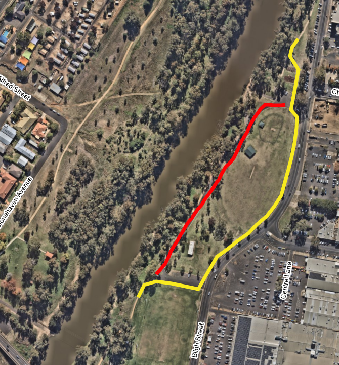
Please view the alternative route mapped out below, so you can continue to use the Tracker Riley loop.
Boat & ramp access during this construction phase will be from Lions Park West.
Public Toilets
Public toilets during this construction can be located at the following locations:
The materials used to develop the shared pathway, cantilevered viewing platforms and the plaza will be able to withstand 1:100 year flooding events; while also being aesthetically pleasing, long life cycle with minimal maintenance. The proposed timber decking for the viewing platforms and seating is Class 1 structural Australian Hardwood that has a life expectancy of 35 to 45 years with limited maintenance; which can be extended with increased maintenance.
Original plans were a boardwalk, lower to the river but this option was discounted due to risks of flooding and the decision to relocate to the top of the bank for a pathway was adopted.
The original concept for a boardwalk was identified in the Macquarie River CBD Master Plan that was developed through extensive community consultation and formally adopted by Council in April 2020. As part of the community consultation leading up to the adoption the master plan, the community identified the development of a boardwalk as the most important element of activating this space. Other elements that the public identified as being important for this space included native corridor plantings, connections to the Tracker Riley Walkway and natural terracing.
Due to design considerations to minimise the risk of flood damage and costly repairs the original position of the boardwalk at the river / bank interface has shifted. Rather than being located at the bottom of the river bank the boardwalk has now been relocated to the top of the bank and has evolved into a Shared Pathway. This pathway will safely accommodate pedestrian and cyclists as well as vehicles that utilise this space.
Signage identifying the proposed Shared Pathway was installed in early 2021/2022 showing an artist’s impression of the area, well as providing a QR code that linked to Frequently Asked Questions about the project.
Project updates
Friday 12 April 2024
Open Ceremony
The shared pathway has been officially opened by the NSW Government and Dubbo Regional Council.
Thursday 28 March 2024
Construction complete
The construction of the Shared Pathway Project is now complete. Community can access this pathway once again. An official opening is planned for the mid April.
Monday 4 March 2024
Closure of North Ollie Robbins Carpark
To allow for the removal of the current road surface and its replacement with concrete to align with the new pathway, the northern car park (located off the lower end of Church Street) will be closed from 4 March 2024 for a duration of 2 weeks.
Monday 30 October 2023
Removal of south fitness node
As a part of the Legacy Shared Pathway project, the south fitness node will be removed and unavailable to public, starting on Monday, October 30th. The north fitness node will still be accessible.
If you're looking for alternative fitness options, you can find two more fitness areas nearby at Victoria Park and Victoria Park 2.
Wednesday 6 September 2023
Temporary pathway
- Back road and boat ramp closed
- Temporary pathway in use
Thursday 17 August 2023
Site Preparation
Preparations will commence for the proposed construction. Community will begin to see the construction of a temporary detour and fencing around the proposed construction site.
Tuesday 11 July 2023 08:00 am to 05:00 pm
Ground testing
We would like to inform community to expect traffic restrictions to the internal Ollie Robbin road. Ground testing along the Shared Pathway route is required to be undertaken along the proposed route prior to the commencement of works.
Proposed impacts to community
The following areas will be impacted by the construction of the Shared Pathway, once underway. Please consider your use of this area and sign up YourSay to ensure you receive updates on this project as it progresses.

Do you have a question?
If there is anything we haven't covered, reach out so we can come back with an answer for you.
To ask a question you must create an account or log in.
These are the people that are listening and responding to your questions.

Engagement & Customer Insights Team
Dubbo Regional Council
Manager Recreation and Open Spaces
Dubbo Regional Council
{{question.description}}


